Maritime Risk &
Threat Intelligence
Dashboard
A real-time, interactive threat assessment platform built for maritime security professionals, shipping companies, and naval operators.
Everything you need for
maritime threat awareness
A complete intelligence suite covering real-time mapping, threat assessment, incident tracking, and secure reporting.
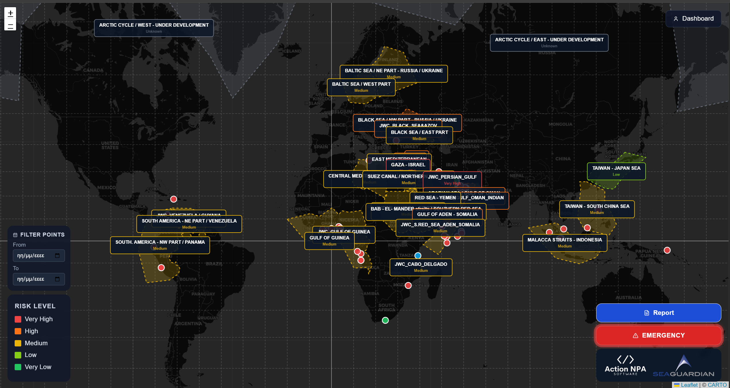
Interactive Threat Map
Full-world interactive map with color-coded risk regions, geographic grid, and real-time vessel/incident point tracking. Powered by Leaflet.
Threat Data Analytics
Detailed breakdown of threat categories per region: military/terrorism, piracy, hijacking, and GNSS/GPS interference — with historical data tracking.
Custom Point Tracking
Plot and manage custom points on the map — vessels, incidents, or assets — with status indicators (Friendly, Cooperative, Distressed) and date filtering.
Emergency Alert System
One-tap emergency beacon with GPS auto-fill. Instantly notifies maritime authorities with the vessel's location and reporter information via email.
Incident Reporting
Secure in-app report submission with optional file attachment. Reports are delivered directly to your designated security team email.
Role-Based Access Control
Three access levels — Admin, Editor, and Viewer — with full session management, audit logging, and secure token-based authentication.
AI-Assisted Analysis
Built-in AI analysis tools to assist intelligence officers in generating threat assessments and region reports faster and with greater accuracy.
Historical Threat Records
Full history of threat data updates per region, allowing trend analysis and retrospective intelligence reporting over time.
WordPress Plugin
Delivered as a WordPress plugin — installs in minutes, integrates seamlessly with your existing website with no separate hosting required.
Five-tier risk level system
Every monitored region is assessed and color-coded across five standardised risk levels for immediate situational awareness.
Operational in three steps
From installation to live intelligence — up and running in under an hour.
Install the Plugin
Upload the WordPress plugin to your site. Tables are created automatically on activation. No external database setup required.
Configure Your Regions
Draw maritime regions directly on the map, assign risk levels, write threat assessments, and set up your security team email alerts.
Deploy to Your Team
Create user accounts for your team with appropriate roles. Share the map URL — your live intelligence dashboard is ready.
Built for maritime professionals
Designed for organisations that operate in, or monitor, high-risk maritime environments.
Shipping Companies
Monitor all active routes and regions where your fleet operates. Get immediate visibility on threat escalations before they affect operations.
Maritime Security Firms
Deliver professional-grade threat intelligence to your clients through a branded, private platform. Manage assessments, teams, and reporting in one place.
Naval & Coast Guard Units
Track vessels, incidents, and patrol assets in real time. Emergency alerts go directly to your operations centre for immediate response.
Ready to secure your
maritime operations?
Contact the Sea Guardian team to request access or arrange a live demonstration of the platform.
Get in Touch →